Image of the City: Healthcare Precincts of Delhi
The article emphasises on measuring the elements of urban design in the line of ‘The Image of the City’ by Kevin Lynch, whereby the locational setting shifts to various pockets of New Delhi that are impactful primarily because of the presence of healthcare centres which are of regional or national importance.
City design is the amalgamation of different elements including utilities, transportation, landmarks and meeting places stated in different ways by various noblemen. The different elements have to be arranged in a manner that they speak for a city and are functional to the users. People are the most important part of a city, not only acting as spectators but an evident part of the growth that it witnesses.
The article focuses on studying and analysing the urban precincts of the healthcare institutes of Delhi and developing a site-specific urban design proposal for the enhancement of the ward. The study envisions to undertake area-specific ward design in the national capital territory to present comprehensive policies and proposals for the upgrading of the wards. The project focused on studying the area of intervention by adopting certain methodologies which included the understanding, on how the national capital territory came into existence, the urban morphology of Delhi, selection of case study areas, analysis of the urban profile of the wards, interpreting the image of the city – by Kevin Andrew Lynch and finally trying to co-relate the inferences with our project.
The project was divided into different stages to be well versed about the entire flow of proceedings, like the preparatory stage wherein selection of the top five hospitals in Delhi was done followed by the background study stage which dealt with understanding the importance of different healthcare institutes on the city level, a study of the historical background and current scenario of Delhi. After this came the analysing stage which focused on studying the elements of urban design according to Kevin Andrew Lynch. Lastly, in the application stage all these inferences were applied to the different wards and observations were recorded. As urban development of any city creates a different morphology of the urban precincts with its growing neighbourhood. With a rapid increase in urbanization, the planners are hoping for a utopian city which is an oddity and stated as an impossibility by many (Delhi Urban Art Commission, 2015). Studying such projects helps one to understand the problems associated with it and also to come up with appropriate solutions.
Delhi had a traditional urban design which is reflected in the glory of seventeenth century Shahjahanabad and New Delhi. Over time Delhi is becoming an indeterminate form of built and open spaces. This study is to review the rapid urbanization and proliferation of uncontrolled settlements in Delhi and shed some light on the characteristics of its urban precincts.
Discussing the historical context, during the eighth–eleventh century Tomar Dynasty ruled over Delhi and they also dominated as generals of the Pratihara kingdom of Kannauj. Before the origin of the fortified city of Lalkot as a new-born capital during the eleventh century (Figure 1). (Delhi Urban Art Commission, 2015)
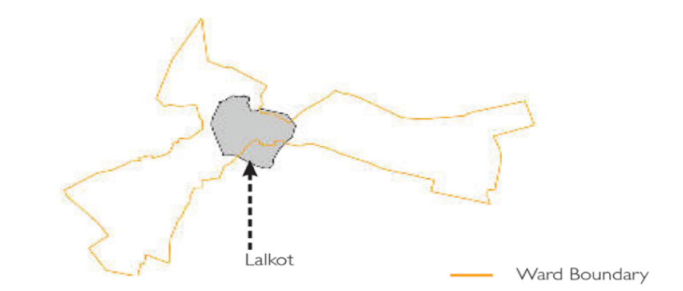
Source: Delhi Urban Art Commission (DUAC), 2015
During the twelfth century, Chauhan Rajput’s defeated the Tomars under the guidance of Prithvi Raj Chauhan and mounted the Qila Rai Pithora as a new extension to the city of Lalkot (Figure 2).

Source: Delhi Urban Art Commission (DUAC), 2015
During the thirteenth century, the Slave Dynasty ruled over Delhi. The Qutub complex was constructed in this era. The village of Mehrauli grew across the shrine of Saint Qutubuddin Bakhtiyar Kaki in 1235 CE (Figure 3) (Delhi Urban Art Commission, 2015).
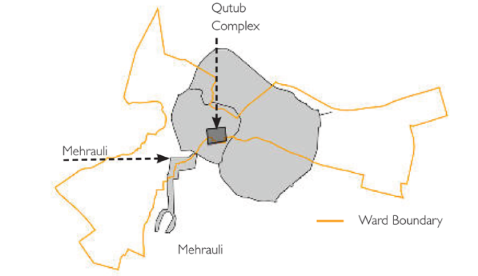
Source: Delhi Urban Art Commission (DUAC), 2015
During the fourteenth-eighteenth century, Lado Sarai was constructed as a night-time safe shelter for the passengers using city’s essential thoroughfare (present day Mehrauli–Badarpur Road) to Tughlaqabad. In the late Mughal era, the population across the Lado Sarai and Mehrauli extended as a new thoroughfare from Shahjahanabad to Mehrauli (present-day Aurobindo Marg) was constructed (Figure 4) (Delhi Urban Art Commission, 2015).
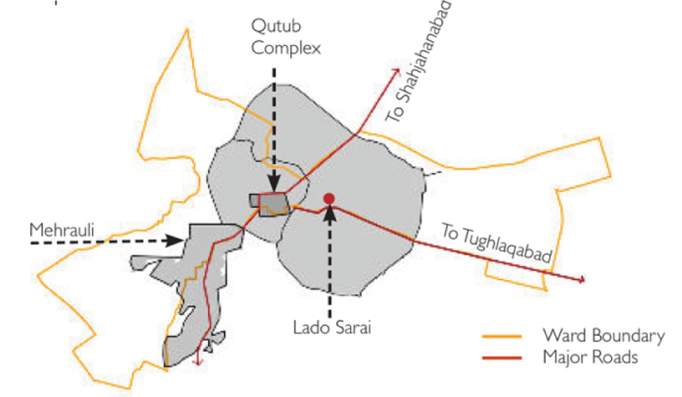
Source: Delhi Urban Art Commission (DUAC), 2015
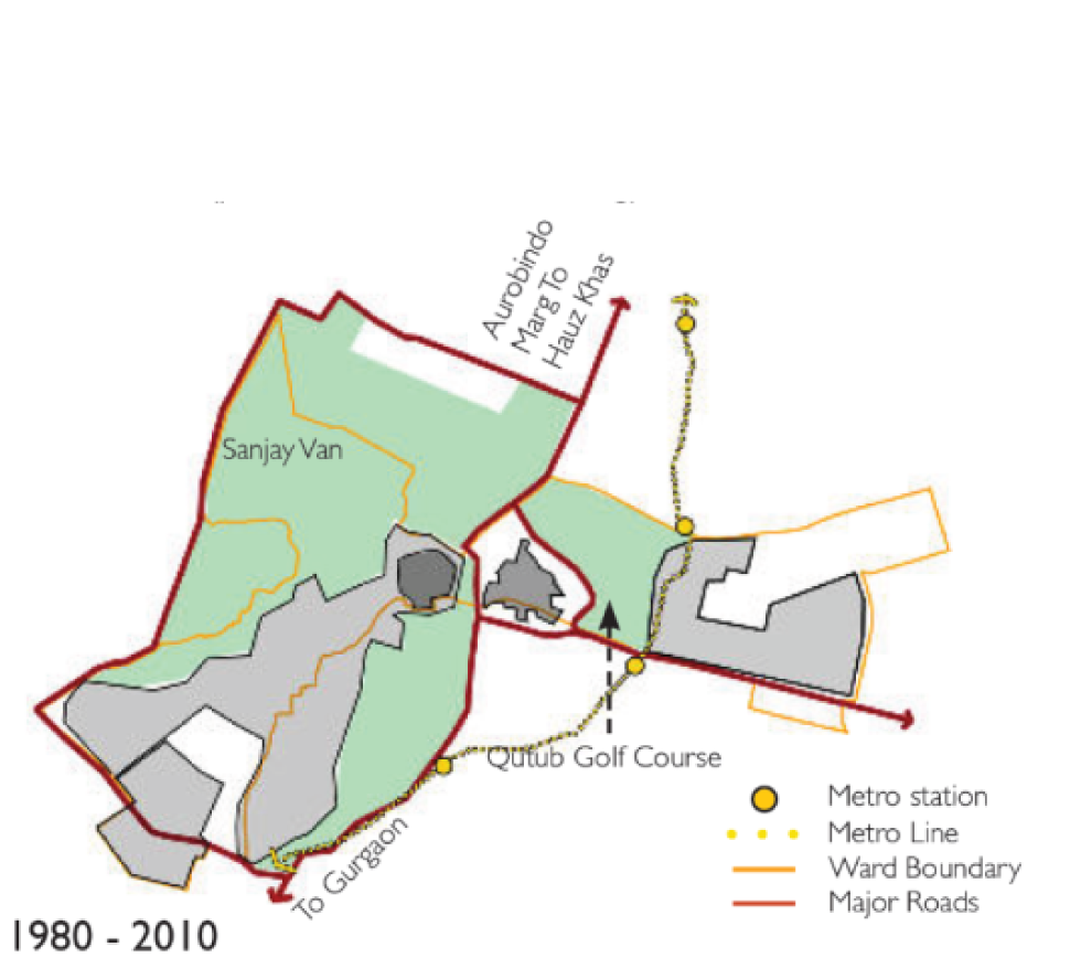
During the twentieth century, the Delhi Development Authority (DDA) initiated its new master plan in 1962 and Mehrauli–Badarpur road and Aurobindo Marg had been earmarked as inter-town motion arteries. Planned areas of Saket and Vasant Kunj were colonized and constructed at some stage between the 1970s and 80s (Figure 5). During this era, the rural land around Lado Sarai and Mehrauli was acquired by the DDA and marked as the Qutub Golf Course, Mehrauli Archaeological Park and Sanjay Van to preserve heritage monuments and to add flora and fauna (Delhi Urban Art Commission, 2015). The yellow line of Delhi metro came up inside the region in the year 2010 (Figure 6).
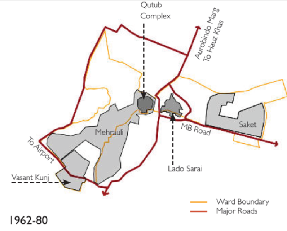
Source: Delhi Urban Art Commission (DUAC), 2015
Municipal Corporation of Delhi (MCD) came into existence on the 7 April 1958 under an act of Parliament. Earlier Delhi Municipal Committee (DMC) was the principal civic body of Delhi (Hindustan Times, 2017). In the current context, the Municipal Corporation of Delhi (MCD) is an independent body that governs eight of the eleven districts of the union territory of Delhi. It is one of the three municipal bodies in the National Capital Territory of Delhi (NCTD), the others being New Delhi Municipal Council (NDMC) and Delhi Cantonment Board (DCB) (Department of Law, Justice & Legislative Affairs, 2011).
Source: Delhi Urban Art Commission (DUAC), 2015
On 13 January 2012, the Municipal Corporation of Delhi was ramified i.e. split into three smaller municipal corporations. The new South Delhi Municipal Corporation (SDMC) and North Delhi Municipal Corporation (NDMC) contain 104 municipal wards each while the East Delhi Municipal Corporation (EDMC) comprises of 64 wards respectively (Economic Survey of Delhi, 2017). Thus, the entire city of Delhi is serviced by the following urban local bodies:
- North Delhi Municipal Corporation (NDMC),
- South Delhi Municipal Corporation (SDMC),
- East Delhi Municipal Corporation (EDMC),
- New Delhi Municipal Council (NDMC), and
- Delhi Cantonment Board (DCB)
Delhi Development Authority (DDA)
Delhi Development Authority (DDA) is entrusted with the responsibility of planning for urban growth in the city. It is mandated to organize and structure the growth and expansion of the city-state. Delhi is further divided into different districts, zones, sub-zones and wards under the DDA and MCD (Table 1 and Table 2).
| No. | District | District HQ | Population (2011) |
|---|---|---|---|
| 1 | Central Delhi | Daryaganj | 5,82,320 |
| 2 | East Delhi | Preet Vihar | 17,09,346 |
| 3 | Shahdara | Shahdara | |
| 4 | New Delhi | Connaught Place | 1,42,004 |
| 5 | North Delhi | Narela | 8,87,978 |
| 6 | North East Delhi | Seelampur | 22,41,624 |
| 7 | North West Delhi | Kanjhawala | 36,56,539 |
| 8 | South Delhi | Saket | 27,31,929 |
| 9 | South West Delhi | Dwarka | 22,92,958 |
| 10 | South East Delhi | Defence Colony | |
| 11 | West Delhi | Rajouri Garden | 25,43,243 |
Source: Census of India, 2011; Delhi Development Authority (DDA)
| No. | Zone | Locale | Area (ha) |
|---|---|---|---|
| 1 | A | Old City | 1,159 |
| 2 | B | City Extension (Karol Bagh) | 2,304 |
| 3 | C | Civil Line | 3,959 |
| 4 | D | New Delhi | 6,855 |
| 2 | E | Trans-Yamuna | 8.797 |
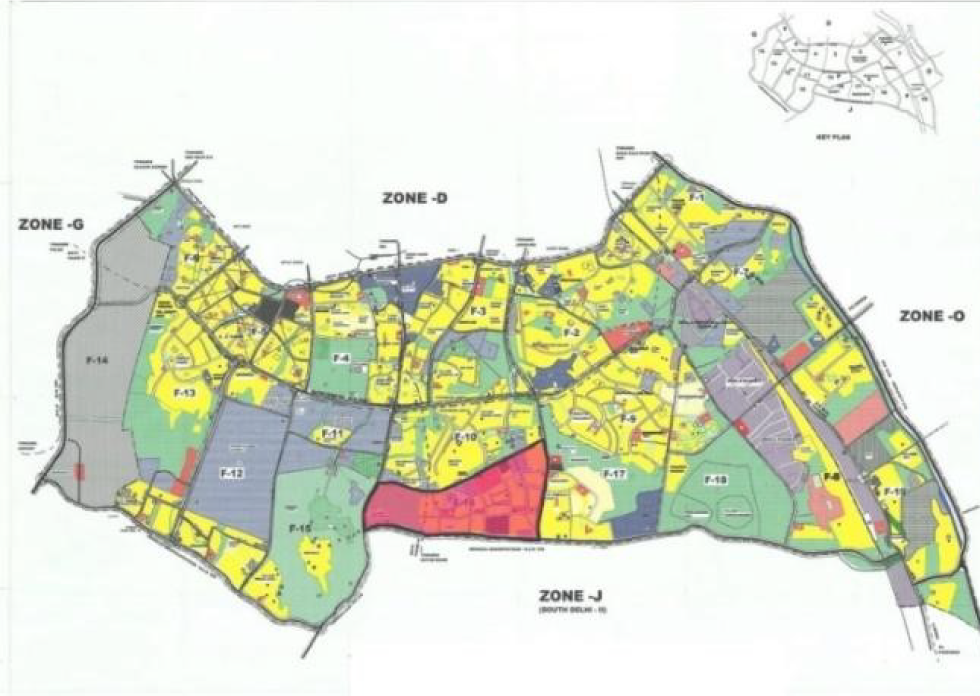
| 3 | F | South Delhi-I | 11,958 |
| 4 | G | West Delhi-I | 5,677 |
| 5 | H | North West Delhi-I | 15,178 |
| 6 | J | South Delhi-II | 22,979 |
| 7 | K | South West Delhi | 8,213 |
| 8 | L | West Delhi-II | 8,213 |
| 9 | M | North West Delhi-II | 15,851 |
| 10 | N | North West Delhi-III | 6,081 |
| 11 | O | River Yamuna | 15,707 |
| 12 | P | North Delhi | – |
| 13 | M, N & P (Part) | Narela Subcity | – |
| TOTAL | 1,48,639 |
Source: Zonal Development Plans, Delhi Development Authority (DDA)
For carrying on the research forward the medical institutes were selected considering their impact on the surroundings, the city (urban precincts) and lives of people. Noticing their existence in different zonal locations of Delhi in different ward precincts. Thereby, scrutinizing the kind of ownership these medical institutes hold. Importance of these hospitals on city and national level has been taken into cognizance. After selecting the areas of intervention for analysis, certain pointers were kept in consideration while exploring the individual urban precincts. Some of them were considering the built and unbuilt area, emphasis on green cover, connectivity, landmarks, residential density, edges, present condition of pathways and surroundings affecting the area of study.
| Hospital Name | Zone | Sub-Zone | Ward | Ward No. |
|---|---|---|---|---|
| All India Institute of Medical Sciences (AIIMS) | F | F-03 | Hauz-Khas | 62-S |
| Max Super-Specialty Hospital | F | F-16 | Lado-Sarai | 63-S |
| Fortis Hospital | H | H-06 | Shalimar Bagh South | 63-N |
| Sir-Gangaram Hospital | B | B-02 | Rajendra Nagar | 102-N |
| Rajiv Gandhi Cancer Hospital | H | H-08 | Rohini-B | 25-N |
Source: Ward Division Data, Municipal Corporation of Delhi (MCD); Zonal Development Plans, Delhi Development Authority (DDA)
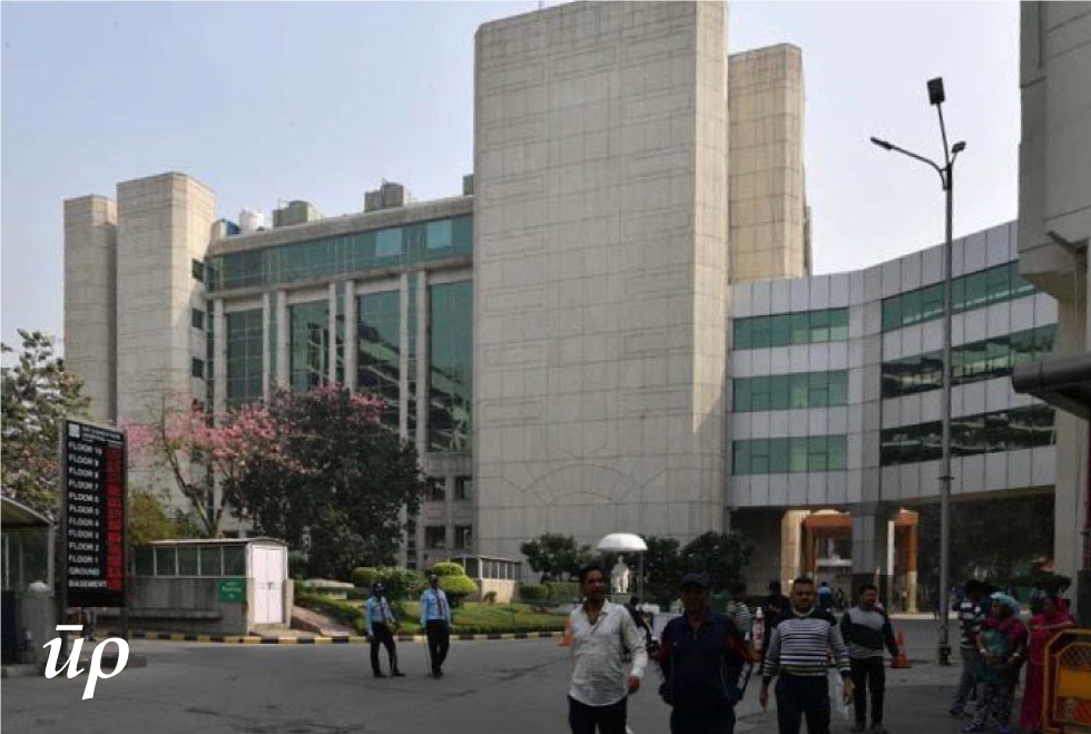
All India Institute Of Medical Sciences (AIIMS)
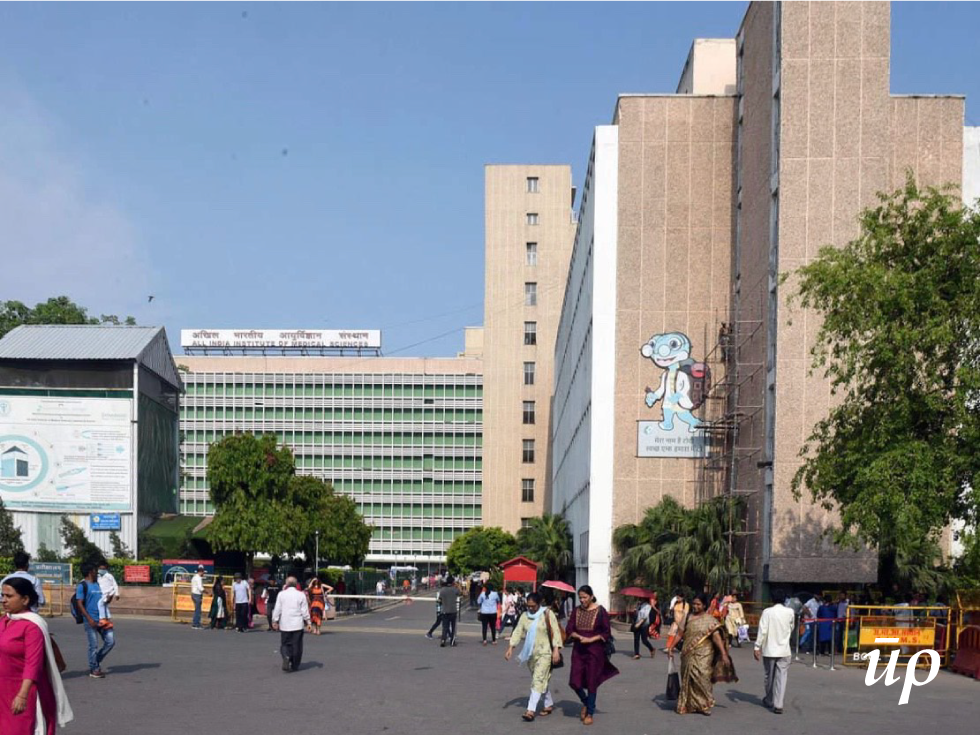
Picture: Rishabh Thakur
It was established in 1956 and is managed autonomously under the Ministry of Health and Family Welfare (MoHFW), Government of India. It is amongst the most prestigious medical institutes in India and holds a prominent position at the global and national level. It serves patients at an integrated ‘one campus’. It answers to all issues faced by the patients namely physio-therapeutic, operative, rehabilitative, investigative; ensuring smart mobility and accessibility for the patients. Tunnel and ramp road link between east campus and Jai Prakash Narayan Apex (JPNA) trauma centre facilitates better connectivity in the surrounding precincts.
Source: Zonal Development Plans, Delhi Development Authority (DDA)
Source: Geospatial Delhi Limited
Max Super Specialty Hospital
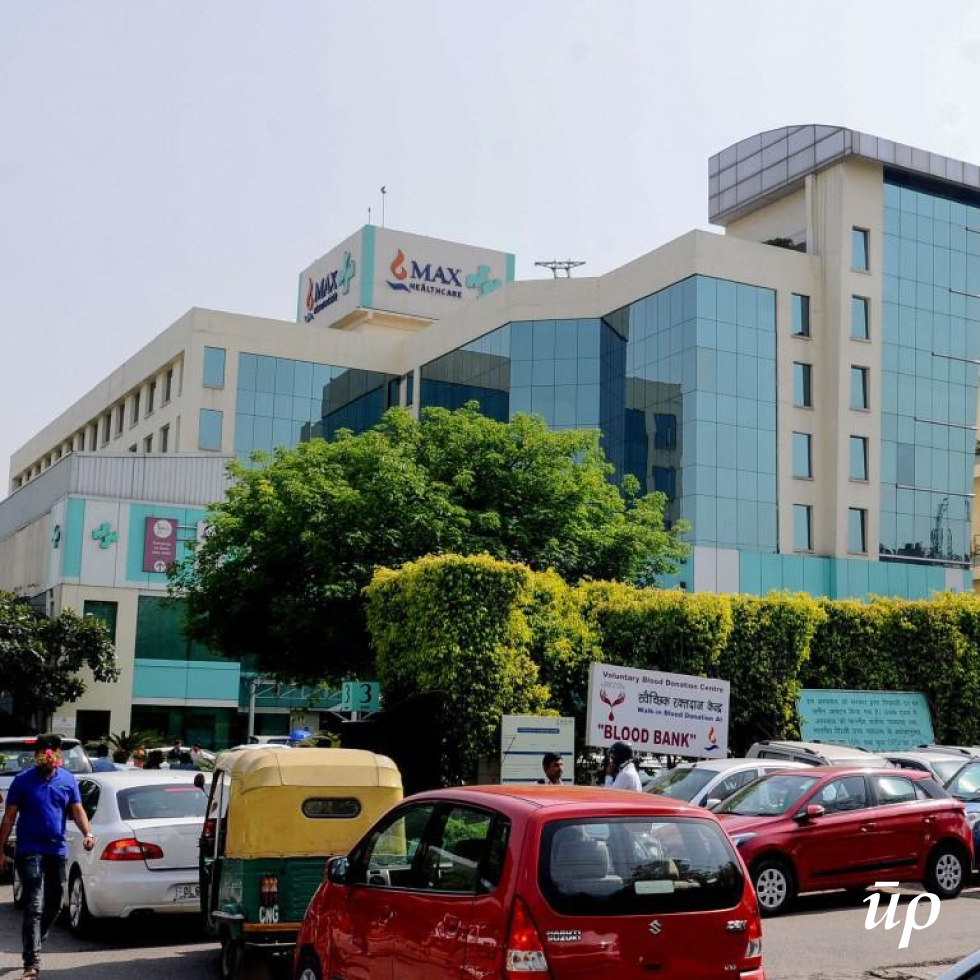
Picture: Anil Kumar
Max Super Speciality hospital located in Saket is amongst the best private hospitals of Delhi. It provides patients with world-class care, efficient discipline & hygiene. It’s an important hospital serving patients from all over the world and is surrounded by a high density of residential areas. Due to its expansion various travel agencies, currency exchange points and food outlets have emerged in the urban precincts to cater to the needs of users. Being a remarkably designed and aesthetically pleasing space, it modulates the aesthetics of the surroundings.
Source: Zonal Development Plans, Delhi Development Authority (DDA)
Source: Geospatial Delhi Limited
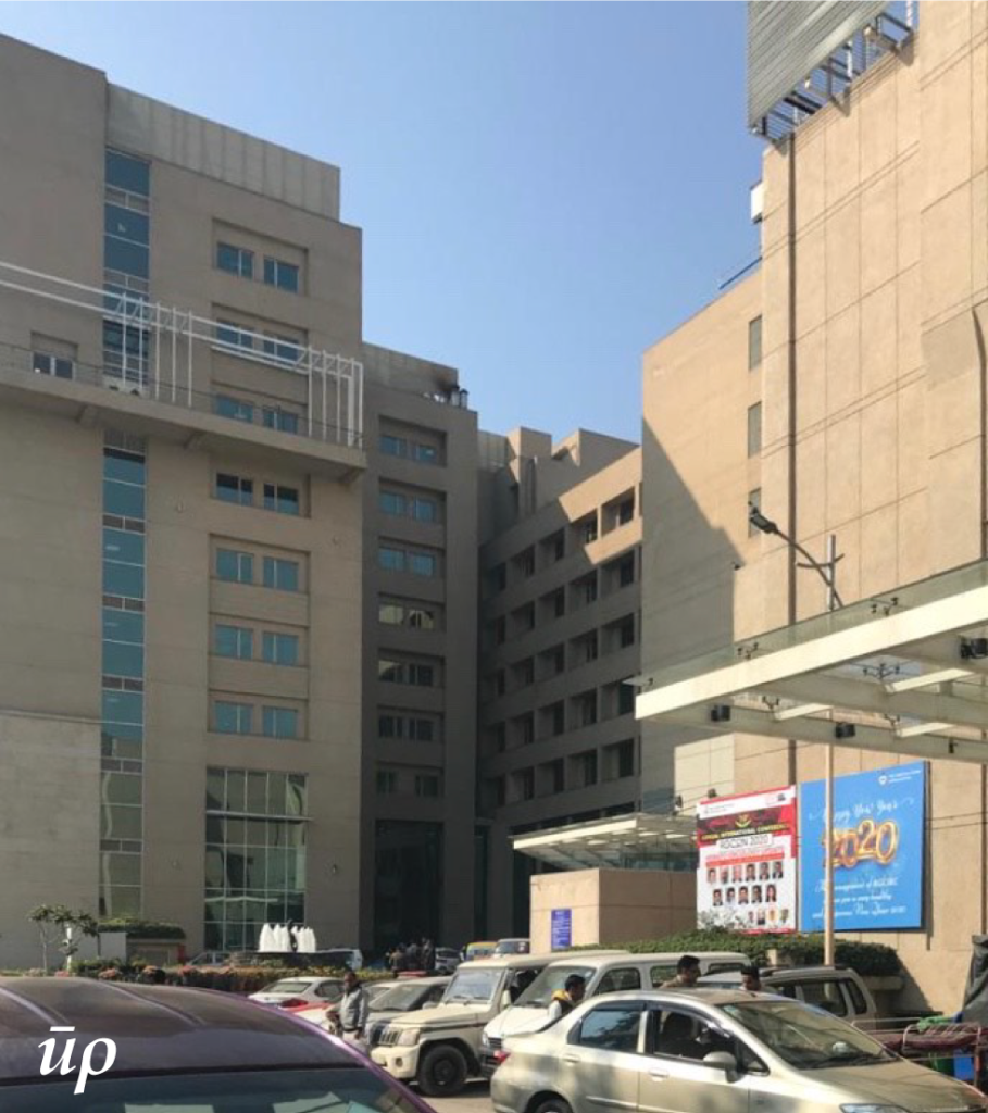
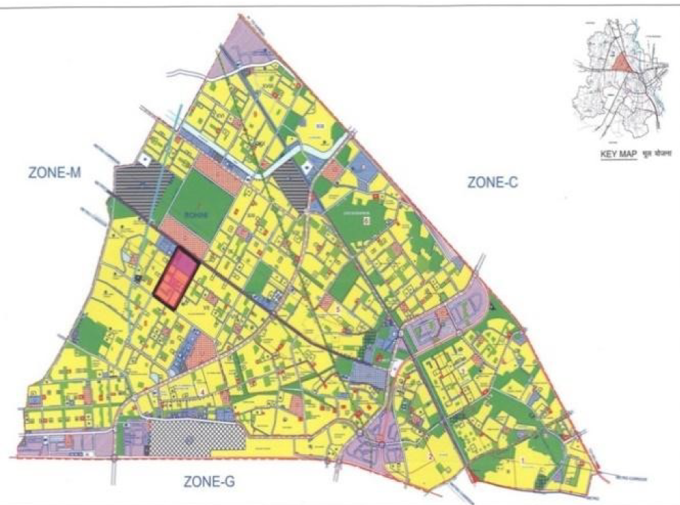
Sir Ganga Ram Hospital
Picture: Anil Kumar
Sir Ganga Ram hospital is a multi-speciality hospital in Delhi-NCR serving numerous patients, at the city as well as national level, with different disabilities and issues. It provides comprehensive medical services to patients from all over the south-east Asia. It is the only hospital in the private sector that has maintained nearly 100 percenr bed occupancy due to its reputation of providing the highest level of medical services to patients in the city of Delhi and neighbouring states.
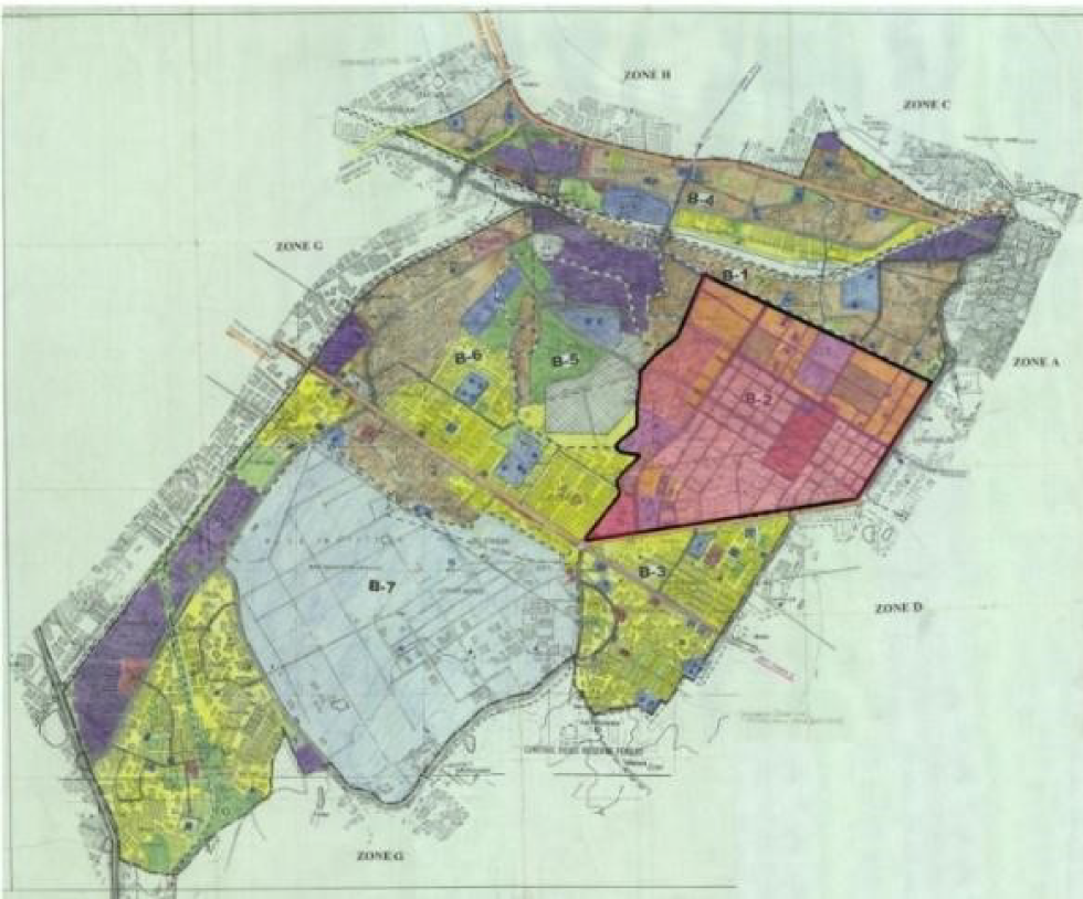
Source: Zonal Development Plans, Delhi Development Authority (DDA)
Source: Geospatial Delhi Limited
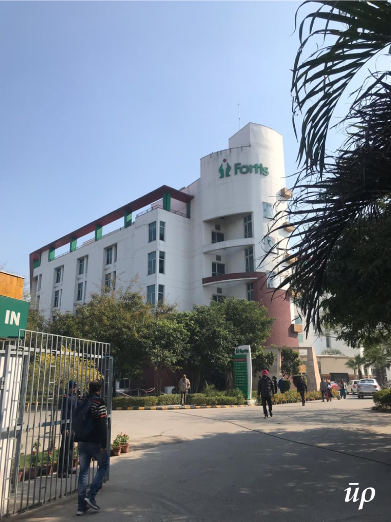
Rajiv Gandhi Cancer Hospital
Picture: Swarna Joshi
Rajiv Gandhi Cancer Institute & Research Centre is counted amongst Asia’s premier exclusive cancer centres. It offers the unique advantage of cutting edge technology, put to use by renowned super-specialists. The institute offers specialized tertiary care services in medical, surgical and radiation oncology departments through dedicated teams.
Source: Zonal Development Plans, Delhi Development Authority (DDA)
Source: Geospatial Delhi Limited
Fortis Hospital
Picture: Saurav Bhagria
Fortis hospital provides comprehensive care in over thirty specialities, state-of-the-art infrastructure and world-class technology. It attracts patients from all around Delhi leading to an increase in the land value of the surrounding area which is predominantly residential. It’s the only hospital in the area that treats all kind of medical issues and it is very easily approachable.
Source: Geospatial Delhi Limited
After having finalized the areas of study, an important part of the research was to refer to world-renowned texts to understand the terminology and methodology used by the stalwarts of the design community. Reading and taking insightful inferences from the book, ‘The Image of the City’ by Kevin Andrew Lynch (1918-1989), a pioneer in urban design, helped in understanding the urban precincts better.
Kevin Andrew Lynch formulated certain terminologies that are globally accepted to understand and perceive the ‘image of a city’ as an observer. Studying these elements one comes to scrutinize the intricacies of the planning process. The terminologies are listed as follows:
Paths: The channels along which the observer customarily, occasionally, or potentially moves. They may be walkways, streets, transit lines, canals or railroads.
Edges: The linear elements not used or considered as paths by the observer. They are the boundaries between two phases of the places, linear breaks in continuity for example shores, railroad cuts, edges of development, walls, barren lands or canals.
Districts: The medium-to-large sections of the city, conceived of as having a two-dimensional extent, in which the observer mentally enters “inside of,” and which are recognized as having some common identifying character.
Nodes: The strategic spots in a city into which an observer can travel through, and which are the intensive foci to and from which he is travelling.
Landmarks: Another type of point-reference, but in this case, the observer does not enter within them. They are usually a rather simply defined physical object: building, sign, store, or mountain.

Source: The Image of the City, Kevin Andrew Lynch
Lynch concluded that people form mental maps of the surroundings consisting of five basic elements- nodes, landmarks, pathways, districts, edges. Mental map is a person’s point of view about their area of interaction, which is forming an image of a city’s architectural and urban components to direct his motion. Lynch’s analysis holds a major role in understanding the evolution and development of the city through its basic elements.
None of the Lynch’s element exists in isolation. Each of them complements and relates to the other in one or the other way. All of them combine to form an image of the city or image of our area of intervention.
Five different wards in the city of Delhi were studied as part of this study and the five Lynch elements were looked for in these areas.
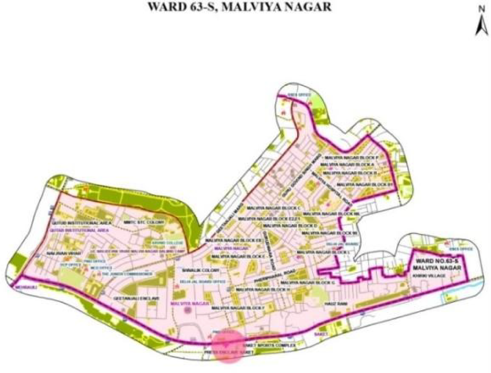
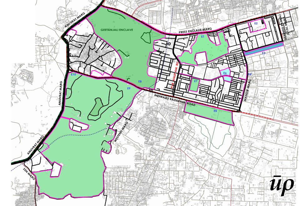
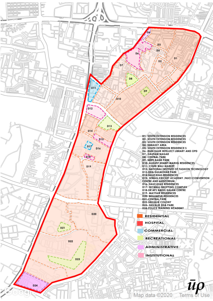
Ward Lado Sarai (67-S)
This ward was looked into because of the presence of the Max Super Speciality hospital, which holds a profound impact at the regional level. Two different morphologies that prevailed in this area of the search were the Lado Sarai Basti and city with its contrasting nature. They had to be dealt with different methods of understating the five elements.
Compilation: Author
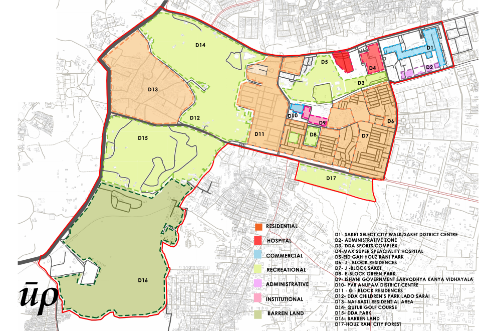
Compilation: Author
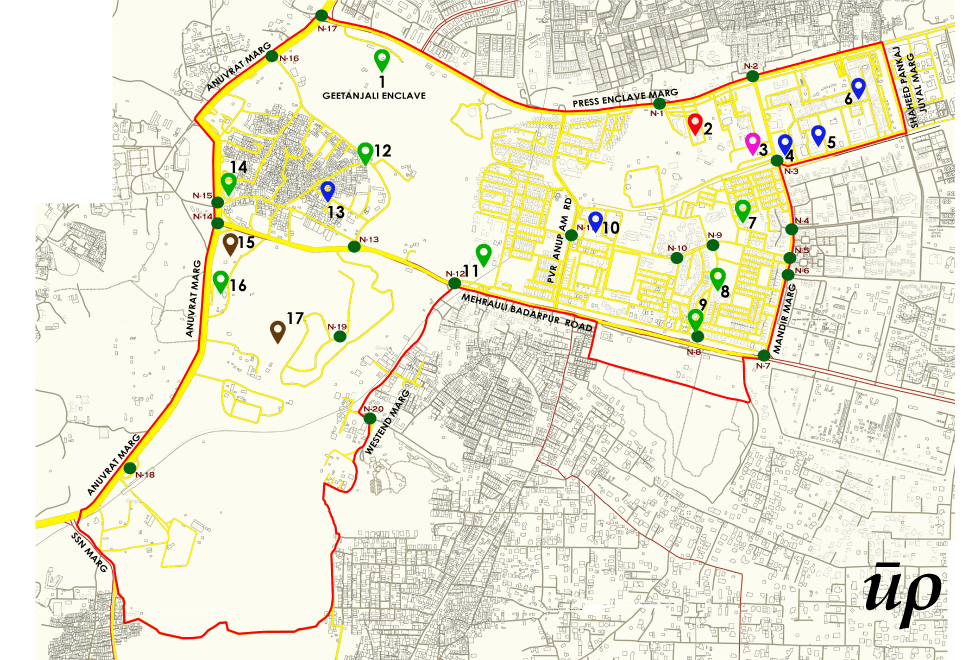
Compilation: Author
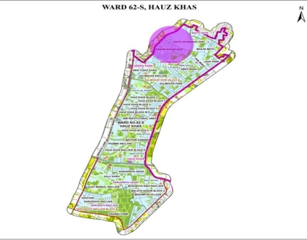
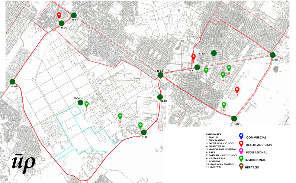
Ward Hauz Khas (62-S)
The ward was looked into because of the presence of the All India Institute of Medical Sciences (AIIMS) . The area of search held a lot of important landmarks, main arterial and connecting roads which made a lot of difference for all the five Lynch elements.
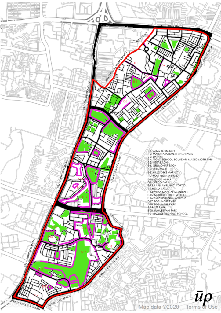
Compilation: Author
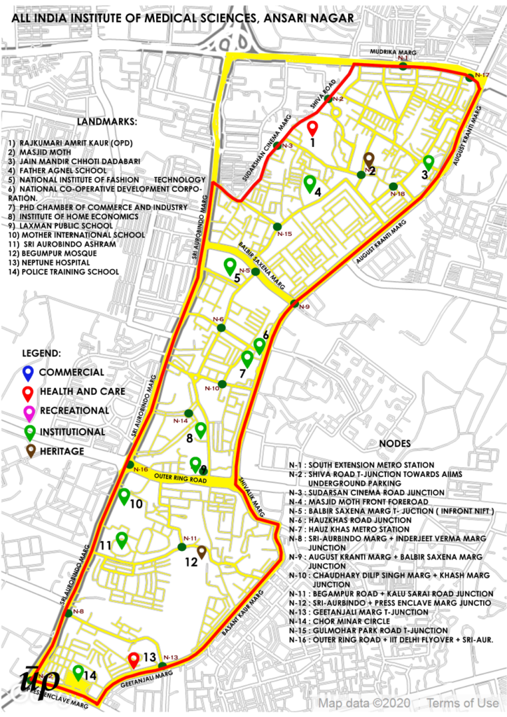
Compilation: Author
Compilation: Author
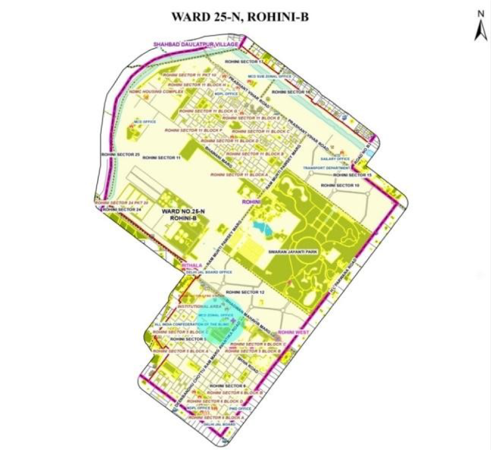
Ward Rohini-B (25-N)
The ward was looked into because of the presence of Rajeev Gandhi Cancer Hospital. The edges and green spaces are really important in this area as these hold a major importance to the people residing in the area. Prominent green edges include the Japanese Park, Adventure Island and Tiger Safari.

Compilation: Author
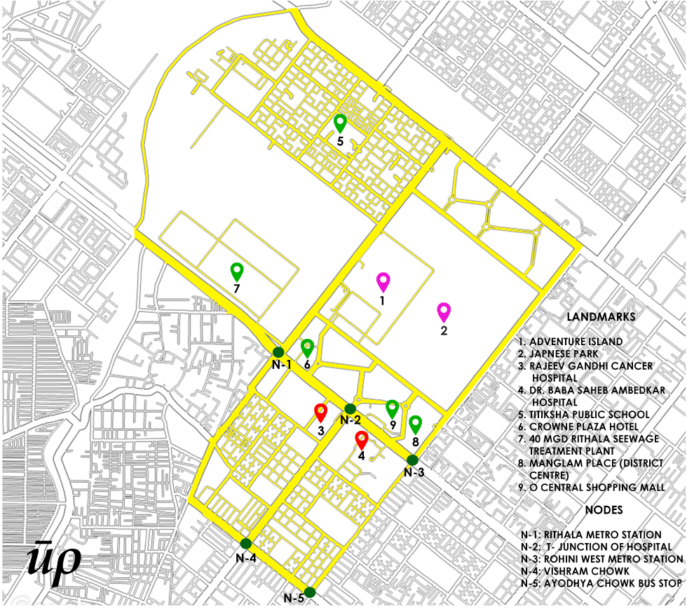
Compilation: Author
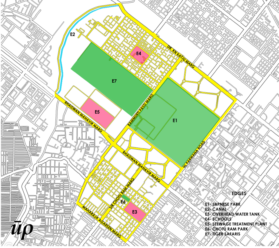
Compilation: Author
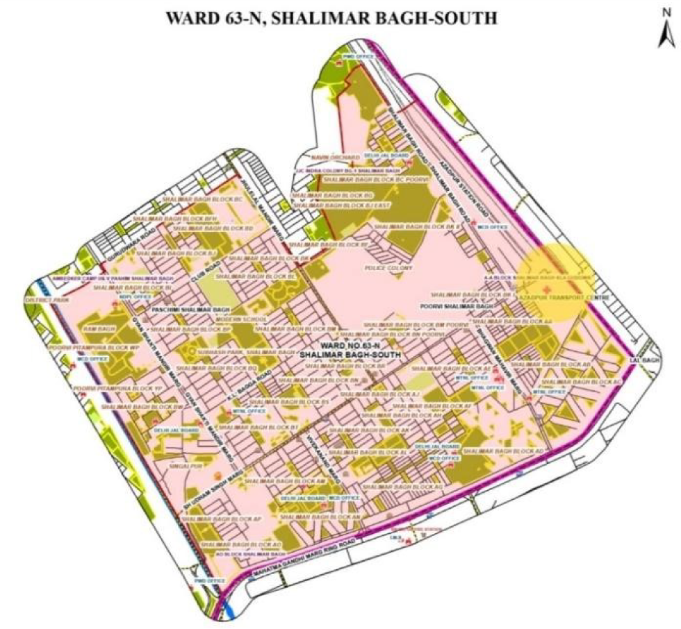
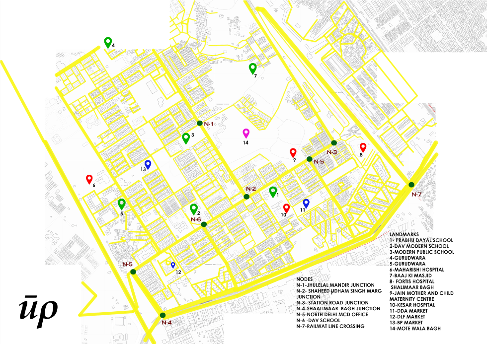
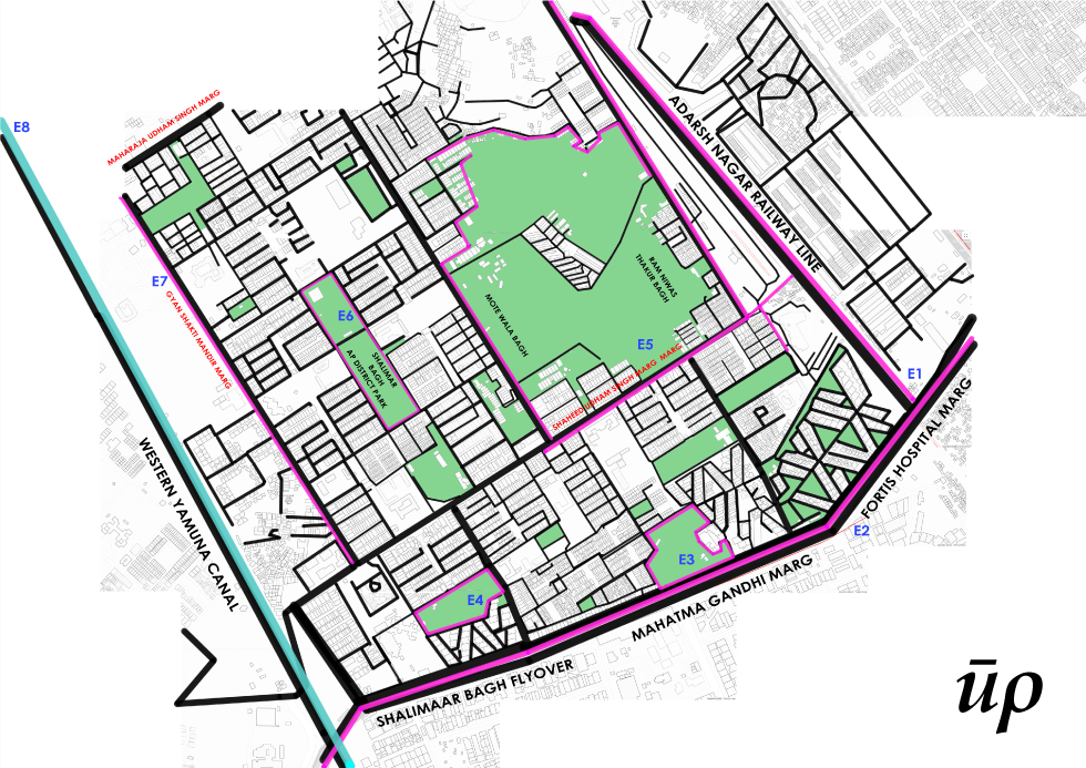
Ward Shalimar Bagh South (63-N)
This ward was looked into because of the presence of Fortis Hospital. The most important Lynch element associated with this ward and hospital was the railway line adjacent to the hospital. The location of hospital being on the dead-end of a road made a lot of difference in the whole study of the ward and the exercise of analyzing five Lynch elements.
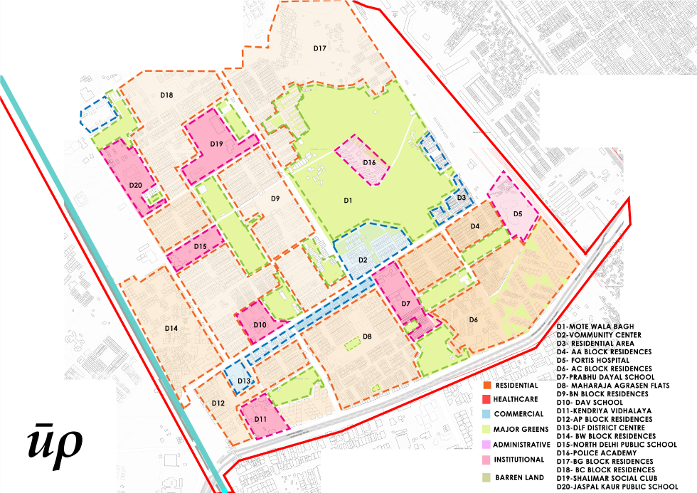
Compilation: Author
Compilation: Author
Compilation: Author
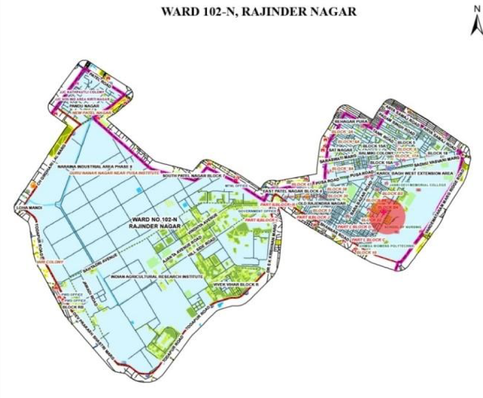
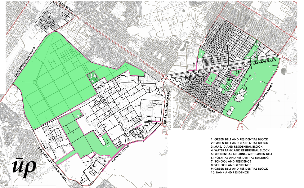
Ward Rajinder Nagar (102-N)
This ward was looked into because of the presence of Sir Ganga Ram hospital. The area was surrounded by residential spaces opposite to the hospital and hospital acting as a landmark for the nearby area.
Compilation: Author
Compilation: Author
Compilation: Author
The comprehensive study of the Lynch elements helped in forming an image, that highlighted better scope for improvement and intervention on the neighbourhood level in certain wards. Therefore after carefully scrutiny of all the possibilities a few conclusions were drawn, a measure to understand the existing work, that had been done on the ward level in the past, was adopted and observations were recorded in the form of literature reviews.
These reviews focus on key factors like execution and deployment of an urban level project and at the end provide reliable resources to formulate similar projects for other urban villages present in the underlying fabric of the country.
The article, therefore, aims to be a credible example in adopting similar strategies for the improvement of civic amenities in urban villages. It defines realistic objectives and goals that can be undertaken for the functioning of activities and projects based on community mobilization and participation. The methodologies adopted are inclusive of several stakeholders which further make the entire procedure to be transparent and comprehensible to people at all levels. The article focuses on the up-gradation of other areas but also seeks out to try and experiment with different technologies, methods and practices that can be potentially extracted from the above mentioned approaches and applied in suitable ways.
References
Delhi Urban Art Commission (2015), City-level projects – Lado Sarai site-specific design for ward number 169
“The Delhi Municipal Corporation (Amendment) Act 2011(Delhi Act 12 of 2011)”. delhi.gov.in. Department of Law, Justice & Legislative Affairs. 29 December 2011. Archived from the original on 24 March 2017. Retrieved 24 March 2017
“Economic Survey of Delhi 2014 – 2015” (PDF). Government of NCT of Delhi. p. 1. Retrieved 23 March 2017.
“Delhi in 70 years.”, Hindustan Times, 15 August 2017.
“DDA at a Glance”. Delhi Development Authority. Retrieved 10 March 2018.
Lynch, Kevin (1960). The Image of the City. The MIT Press. ISBN 0-262-62001-4. Lado sarai urban improvement project –GREHA – July 2015
Credits
Author(s): Anil Kumar, Mehika Saxena, Kanika Jain, Saurav Bhagria, Swarna Joshi, Rishabh Thakur, Students Batch 2016-21, Gateway College of Architecture and Design (GCAD), Delhi NCR
Guide: Ar. Soham Mukherjee, Assistant Professor, Gateway College of Architecture and Design (GCAD), Delhi NCR
We, at Urban Précis, are glad to provide a platform to bring student projects in popular discourse. The project blends theory and practice to map the prominent healthcare infrastructure and its impact on the image of the city of Delhi.


An interesting work by the students of an architecture bachelors course. Very nicely guided by the mentor. Such initations can help promote the aptitude required for social and public architecture. As it is a students’ work, it enables a deeper learning by exposure to greater elements and aspects of urban matrix.